Bryan House Historical Report, Block 14 Building 15A Lot 351Originally entitled: "Bryan Lot Block 14, No. 351"
Colonial Williamsburg Foundation Library Research Report Series - 1294
Colonial Williamsburg Foundation Library
Williamsburg, Virginia
1990
BRYAN LOT
BLOCK 14, N0. 351
The location of this lot in James City County, the records of which have been largely destroyed, complicates the problem of tracing its history.
The earliest available record, the Frenchman's Map (of 1782?) points to a rectangular house facing the Duke of Gloucester Street on the north east corner of the lot and a smaller house directly behind it and at some distance from it. It can then be asserted with much assurance that a dwelling house and one out house were located in this lot in the early 1780's.
This arrangement of the houses and their general dimensions are borne out by drawings found in insurance policies given below.
The first known owner of the lot and buildings was William Bryan, husband of Frances and father of Julian Bryan. On February 26, 1810, in a revaluation of the property for insurance with the Mutual Assurance Society, the appraisers Robert Anderson, Jesse Cole and Francis Timberlake certified:
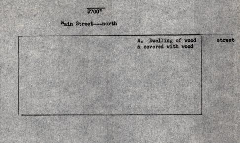
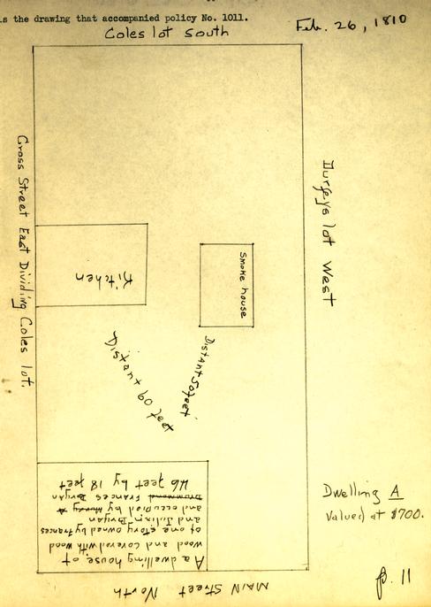
"… we have viewed and revalued the building heretofore declared for assurance by William Bryan then residing at Williamsburg in the county of James City… We also certify that the said building is now owned by Frances Bryan and Julian Bryan that it is now occupied by Murray A. Drummond Frances Bryan and that it is situated south of the main street East of Durfeys lot north of Coles lot and west of a cross Street dividing Coles lots."(Policy No. 1011, p. 11)
The cancelling of the name Drummond in this and the accompanying drawing seems to indicate that the house was leased as a tenement until Frances Bryan occupied it. The phrase used--declared for assurance by William Bryan then living in Williamsburg--rather than 2 a statement that he lived in his house appears significant. Below is the drawing that accompanied policy No. 1011.
Five years later Frances Bryan declared the building for insurance as follows:
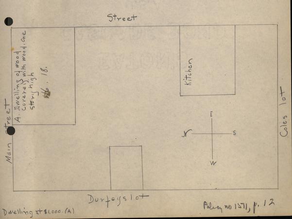
"Frances Bryan, widow of William Bryan and guardian of Julian Bryan residing at Williamsburg in the county of James City do hereby declare for assurance … building on the main street in Williamsburg now occupied by myself situated between Coles lots south and Durfeys lot west in the County of James City."(Policy No. 1511, p. 12., July 5, 1815)
It is impossible to say whether the increased valuation $1,000 was due to additions, depreciation of money due to the War of 1812, or to some other cause. The drawing below accompanied the policy.
On the unknown draftsman's map (dated by Tyler 1790) the name Bryan is shown on this lot, numbered 351. The lot west (unnumbered) has the name "Taliaferro" with a question mark after it. Lot M south of lot No. 351 also bears the name "Taliaferro."

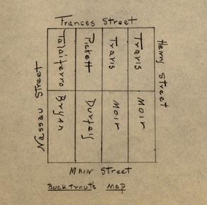
The Bucktrout map of 1800 has no numbers in the lots in Block 14. It shows Durfey west of Bryan and Taliaferro in the lot south.
As Jesse Cole was the owner of Taliaferro's lot in Block 13 in 1815, it may be assumed without much question that he was also the owner of lot No. M, as was suggested in the policy of 1815.
It is probable that William Bryan acquired lot No. 351 from John Lewis, merchant from New Kent. Lewis had stores in James City and New Kent counties in 1767. (Virginia Gazette, Purdie & Dixon, Sept. 10) In the Gazette (Purdie & Dixon) for Feb. 15, 1770, he advertised goods saying that he had removed from New Kent to his house in Williamsburg located on the road to the Capitol Landing. Lewis owned more than one lot in Williamsburg, (York County Records, Book 7, p. 42, Deeds; Book 8, p. 113) although there is no record of his ownership of the lot under discussion.
The Williamsburg Land Transfers (Virginia State Library) for 1795 show that one lot was transferred from John Lewis's estate to William Bryan. Evidently Bryan died before 1797 for in that year his "estate" is credited with 1-¼ lots worth£15. The tax history of the lot is as follows: (Williamsburg Land Tax Records.)
6
No. of Lots Annual Rent of Lots 1785 John Lewis's Est 1-¼ £27 1791 John Lewis's Est 1-¼ £15 1797 William Bryan's Est 1-¼ £15 1801 William Bryan 1-¼ $50 1806 William Bryan's Est 1-¼ $70 1810 William Bryan's Est 1-¼ $67 1812 Do Do Do 1815 Do Do $70 1817 Do Do Do 1818 Jesse Cole 5 230 1-¼ via Frances B. Bryan, house and lot situate on the Duke of Glouster street, bounded on the east by a cross street which divides this lot from Jesse Coles's lot, and on the south by the Baptist meeting house.
Lot Value of lot Sum added by the building 1820 Jesse Cole 1 800 700 Formerly charged to Wm. Bryan's Estate. 1825 " 1 800 700 $60(annl.rent) $1.22 (Tax) 1830 John W. Hutchings 1 800 700 $60 " 1.22 "
Hutchings still owned this property in 1861 when the house was valued at $ 800 and both house and lot at $1200.
Citizens who knew Williamsburg in 1861 remember Hutchings as the owner of lot No. 351. Mr. Charles in his Recollections makes the following comments about this lot: (p. 20)
"On the site of the Person store at N.E. corner of this square, there was, up to about twenty years ago, one of the oldest houses in this ancient city. It was known in later years as the old Hudgins house, as an old fellow named Jack Hudgins lived there and kept a small grocery store with the regulation wet and dry stock.
This old frame house was on a brick work about four feet high, one and a half story, with dormer windows. A wide passage ran through the center, with door opening on Duke of Gloucester street. On the east end was a large room which Old Jack rented out for school, where steps led up from a small open space to the store.
He was known to be high tempered, irritable, and very crabbed."
Hutchings must have been rather eccentric as both Mr. Charles and Mrs. Lee tell anecdotes about him.
Mrs. Victoria Lee also described this house in her Reminiscences, p. 81.
"The southwest corner of Nassau and Duke of Gloucester street was occupied by a small, frame, story and a half house. This house, which stood high above the street, it [sic] was built on a foundation about four or five feet high, had no porch, a flight of steps let directly from the street to the doorway. This house was occupied by a man named Hudgins, who later became postmaster."
A verification of a Hudgins or Hutchings as owner of this lot in the nineteenth century is found in a footnote to policy No. 1011. This footnote reads, "Revalued No. 5019 in the name of Hutchings."
Hunter D. Farish, Director
Department of Research and Record
.38
Sept. 27, 1940
Prepared by Mary McWilliams
Bryan Lot
Mutual Assurance Society Policy #5019 Revaluation of buildings formerly declared by Frances & Julian Bryan &c per declaration #1571
1823, April 13th
"Jesse Cole, the underwritten residing at Williamsburg in the county of James City do hereby declare for assurance … my buildings on my own lot now occupied by Additon Roundtree situated between the lots of my own on the west and south — and street otherwise in the county of James City …"
| The Dwelling | marked A at | $700 |
| $700" |